The European Space Agency (ESA), in collaboration with Airbus, is set to launch Biomass, the world’s largest space-based radar satellite, later this month from French Guiana. As reported by MIT Technology Review, the mission marks a major step forward in our ability to monitor Earth’s forests and their role in capturing atmospheric carbon—by using a part of the radio spectrum that has long been off-limits.
Forests are Earth’s second-largest carbon sink, surpassed only by the oceans. Yet scientists still struggle to quantify how much carbon these ecosystems actually store. The Biomass satellite will help fill that gap by peering beneath dense canopies using P-band radar—radio waves with wavelengths about ten times longer than those currently used in satellite-based Earth observation.
Seeing the Forest and the Trees
Measuring biomass—the total mass of trees and vegetation in a forest—typically requires cutting trees down and weighing them. Since this is clearly impractical at a global scale, researchers rely on remote sensing tools like lidar or aerial surveys. But these tools are limited to accessible regions and can’t penetrate dense tropical forests like those in the Amazon, where only a fraction of the ecosystem has been surveyed on the ground.
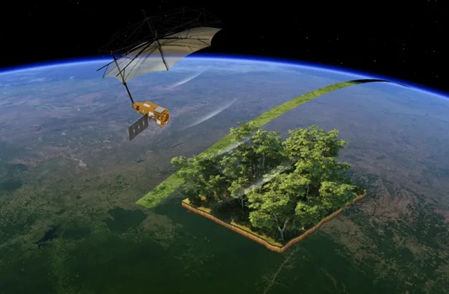
That’s where the Biomass satellite comes in. Its P-band radar can reach beyond the leafy treetops to detect large branches and trunks—the parts of trees that store the most carbon. According to mission manager Klaus Scipal, “To measure biomass, you need to cut the tree down and weigh it, which is why we use indirect measuring systems.”
A Record-Breaking Radar, with Restrictions
To carry the P-band radar, Biomass had to be built larger than most satellites—measuring 12 meters across, mounted on a complex boom that will unfold like a giant umbrella once in space. But size wasn’t the only challenge: using P-band radar in space is generally banned under International Telecommunication Union regulations because the frequency is reserved for powerful ground-based missile-tracking radars, particularly in North America.
To overcome this, ESA negotiated a special exemption, with a major caveat: Biomass must shut off its radar when passing over Europe and North America to avoid interference. “This was a pity. It’s a European mission, so we wanted to do observations in Europe,” Scipal told MIT Technology Review. Still, the rest of the world—including South America, Africa, Asia, and Australia—will be fully observable.
Global Forest Maps in 3D
Once in orbit, the mission will spend its first five months calibrating instruments before entering its “tomography” phase—capturing 3D images of forests by viewing them from multiple angles, much like a CT scan. This process will create hectare-scale maps of forest biomass across previously under-observed regions. Global coverage is expected to take about 18 months.
After that, Biomass will shift to a monitoring mode, generating updated global maps every nine months to track changes in forest density due to deforestation, climate shifts, or fire damage.
“The scientific goal here is to really understand the role of forests in the global carbon cycle,” Scipal said. “The main interest is the tropics because it’s the densest forest which is under the biggest threat of deforestation and the one we know the least about.”
A Giant Leap for Forest Science—with Some Limits
While Biomass is expected to deliver groundbreaking data, it won’t answer every question. For example, it won’t capture seasonal variations in forests or measure carbon stored in soil, particularly in permafrost zones.
Still, experts like Irena Hajnsek, a professor of Earth observation at ETH Zurich, see immense value in the mission. “We’re going to learn how much carbon is stored in the forests and also how much of it is getting released due to disturbances like deforestation or fires,” she said. “And that is going to be a huge contribution.”
By pushing the limits of satellite radar technology and navigating international regulatory hurdles, ESA’s Biomass mission is poised to redefine how we monitor the planet’s most vital ecosystems—from space.