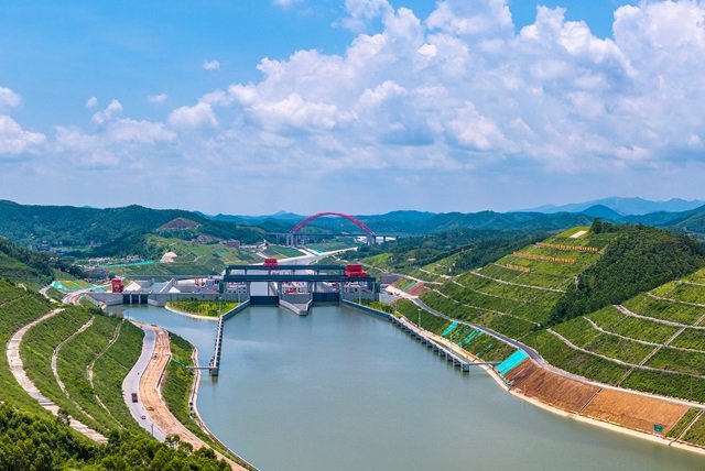
China has opened the Pinglu Canal in Guangxi, creating a direct river-to-sea connection between the country’s southwestern inland waterways and the Beibu Gulf, the northwestern arm of the Gulf of Tonkin between southern China and northern Vietnam. At 134.2 kilometres, the canal cuts more than 560 kilometres from the traditional shipping route linking much of southwest China with the sea.
The waterway, which officially opened to commercial navigation on Wednesday, is the first major river-to-sea canal project planned and coordinated at the national level since the founding of the People’s Republic of China in 1949. It connects the Xijiang River corridor with the Beibu Gulf and is designed to allow vessels carrying up to 5,000 tonnes to travel from inland river networks directly towards maritime routes serving Southeast Asia.
The geographical logic behind the project is straightforward but significant. For decades, cargo from provinces in southwest China had to move eastwards towards Guangdong before reaching the sea. The rivers in the region traditionally flow towards the Pearl River Delta, meaning goods transported by water often travelled towards Guangzhou before having to turn westwards by sea. Pinglu provides a southern alternative, allowing cargo to move towards the Beibu Gulf instead.
The canal begins at the mouth of the Pingtang River in Hengzhou, a city administered by Nanning, the capital of Guangxi, and runs southwards towards the Qin River, which flows into the Gulf of Tonkin, known in China as the Beibu Gulf. Only 6.5 kilometres of the route required excavation across the watershed, with much of the remainder built by widening, dredging or modifying existing waterways.
Its construction has cost about 72.7 billion yuan, while Chinese authorities estimate that the new route will reduce logistics costs by between 18 and 30 percent. Local estimates put annual transport savings at more than 5 billion yuan, or about $700m. Other official estimates have placed the annual saving at about 5.2 billion yuan, or $720m.
Three major navigation complexes — Madao, Qishi and Qingnian — allow vessels to overcome a combined elevation difference of 65 metres. The canal is intended not merely as an isolated waterway but as part of the New International Land-Sea Trade Corridor, a network of railways, roads, ports and waterways designed to connect inland Chinese provinces with Southeast Asian countries and global markets.
The implications extend far beyond Guangxi. Chongqing, Chengdu, Guizhou and Yunnan are among the inland regions expected to benefit, while Hunan is also included in the wider network. Goods can reach Guangxi through existing river and railway connections before continuing towards the Beibu Gulf and overseas markets.
That new route arrives as China’s trade with Southeast Asia continues to expand. According to China’s General Administration of Customs, bilateral trade between China and ASEAN reached about 4.34 trillion yuan, or about $640bn, during the first half of 2026, an increase of 18.2 percent from the same period a year earlier. China and ASEAN have been each other’s largest trading partners for six consecutive years.
The Beibu Gulf is already being developed as an important gateway for that trade. Container-handling capacity at Beibu Gulf Port increased from 2.28 million TEUs in 2017 to about 10.06 million TEUs in 2025. The port now has a shipping network covering major Southeast Asian destinations. Pinglu is intended to enlarge the economic hinterland served by that infrastructure, bringing inland manufacturing and raw materials closer to maritime trade.
Guangxi is simultaneously seeking to build what it calls the “Pinglu Canal Economic Belt”, with industrial activity distributed along the new corridor and connected to ports, transport networks and supply chains. Targeted industries include non-ferrous metals and critical minerals, modern green chemicals, artificial intelligence and information technology. Industrial zones are also being developed close to ports, reducing the distance between production centres and shipping facilities.
Commercial activity has already begun to align with the new infrastructure. A train carrying sodium bisulfate recently travelled from Chongqing to Nanning. Following the canal’s opening, direct commercial sailings are scheduled between Nanning and Can Tho in southern Vietnam. The canal also provides a route to Qinzhou seaport in which river vessels can sail directly to berths without transferring their cargo to other ships.
The authorities have introduced a gradual approach to transit charges. Until December 31, 2026, commercial vessels will pass through the canal’s three water gates free of charge. From January 1, 2027, operators will pay one yuan, about $0.14, for each tonne of vessel capacity each time a vessel passes through the gates. The trial rate is scheduled to remain in effect until September 2031.
Yet the opening of the waterway does not automatically guarantee the commercial transformation promised by its planners. Lei Xiaohua, a researcher at the Academy of Social Sciences of Guangxi, told The Beijing News that bulk cargoes would be “the test of fire” for the claimed cost reductions. Companies, he said, would compare the complete door-to-door cost, including transshipment, storage and the time during which cargo remains immobilised. During the early months, the volume of cargo, land connections and port services will need to develop at a comparable pace. Irregular services or vessels operating with substantial unused capacity could increase unit costs.
The canal has also imposed substantial changes on communities along its route. According to official sources, resettlement involved 2,764 households comprising 11,228 people across four counties and county-level cities in Guangxi. In Hengzhou alone, evacuation agreements were signed for 368 homes, which were demolished across 84,200 square metres, while 1,221 people were temporarily relocated.
Authorities designed 21 housing models around residents’ customs, including the orientation of reception rooms, crop-drying areas, poultry enclosures and agricultural-chemical storage rooms. In Shaping, the largest town involved in the resettlement project, residents received four-storey homes covering 420 square metres, with some properties including commercial storefronts.
In Xinfu, where Fenghuangping village once stood, one displaced resident said: “There is no longer a village called Fenghuangping, but with the Pinglu Canal, tomorrow will be better.” Some families moved centuries-old trees to their new homes, including a 217-year-old camphor tree. The resettlement process was completed within 39 days and was accompanied by promises of construction employment and vocational training.
The project has also attempted to address the environmental consequences of creating a major new waterway. At the Qingnian navigation hub, engineers built a fish passage more than 480 metres long, containing 120 pools, to allow aquatic species to overcome a water-level difference of nearly 10 metres. Monitoring equipment has operated since 2025, recording more than 10 fish species using the passage, with about 76,000 upstream movements and 115,000 downstream movements.
At Fenshuiling, a wildlife-only bridge covered with soil and native vegetation reconnects forest habitats divided by the canal. It is intended to allow leopard cats, masked palm civets and red-bellied squirrels to cross the waterway. A 2025 study published in Land had examined habitat fragmentation across 11 regional wildlife groups and called for ecological corridors to be incorporated into infrastructure planning.
Construction also generated roughly 315 million cubic metres of earth and rock. More than 98 percent was reused for riverbank reinforcement, soil remediation and the creation of about 13,900 mu, or 927 hectares, of farmland.
The opening therefore marks not an endpoint but the beginning of a larger test. Pinglu has been designed to shorten China’s route to Southeast Asian markets, strengthen the connection between inland provinces and the sea, and support industrial development along a new economic corridor. Its long-term performance will depend on whether those promised savings translate into reliable commercial traffic, while its environmental record will depend on continued monitoring of water quality, wildlife movement and coastal ecosystems.
For China, the canal is a new connection between rivers, ports and markets. Along its 134.2-kilometre route, however, it has also created a new set of connections that must be maintained — between economic expansion and communities, and between infrastructure and the ecosystems through which it passes.