


by Durga Velayudham
Sri Lanka is at the blink of another recorded disaster; sooner the blaming and shaming game of usual political catastrophisers will emerge. Failures of the government will try to hide with their prominent propaganda tactics, and the opposition will continue to play heroism: “if we are in power, we will do different.” Yet beneath this exhausting performance of accusation and theatrics lies a far older and far more sobering truth. The island’s history of floods and landslides stretches back more than a century, etched into colonial archives, post-independence district records, and the memories of generations who have watched their homes washed away or buried in the blink of an eye. Sri Lanka’s present is not a sudden catastrophe; it is the latest chapter in a long and deeply rooted story of vulnerability shaped by geography, climate, and human choices.
The earliest detailed accounts of flooding in Sri Lanka come from the British colonial administration, which kept meticulous records of rainfall, crop losses, and damage to infrastructure. These reports describe severe floods in years such as 1913, 1940, 1947, and 1957, when the Kelani, Kalu, Gin, and Mahaweli rivers overflowed and submerged vast stretches of low-lying land. The colonial officers’ diaries note repeated destruction of paddy fields, disruptions to transport routes, and local populations cut off by swollen rivers for days. Even then, there were observations that deforestation in the central highlands, the expansion of tea estates, and the construction of roads without proper drainage had begun to worsen the natural flow of water. Villagers in Ratnapura, Kalutara, and Galle districts frequently reported how once-manageable monsoon rains had started to trigger unexpected local inundations. These early records prove that Sri Lanka’s flood history was already well underway long before modern population pressures intensified the problem.
Landslides, though less frequently documented in the early period, appeared sporadically in colonial records, particularly in the hill country. Plantation managers complained of slopes collapsing after days of heavy rain, damaging tea bushes and cutting off estate roads. Although these incidents rarely caused mass casualties, they were early signs of instability in areas where natural forests had been replaced by monoculture plantations. The systematic study of landslides would come much later, but the seeds of the problem were already planted in the colonial era, intertwined with the economic transformation of the central highlands.
In the decades following independence, floods became increasingly disruptive as the island’s population expanded and settlements spread into vulnerable areas. Severe flood events in the 1960s and 1970s repeatedly affected the south-western river basins, with the 1969 and 1978 floods causing widespread displacement. Entire villages were inundated, bridges collapsed under the force of rising waters, and urban areas struggled with inadequate drainage. Still, despite the growing evidence, flood management remained mostly reactive, focused on relief once the damage had been done.
It was not until the 1980s that landslides emerged as a distinct national hazard demanding focused attention. The deadly landslides of January 1986, which killed more than fifty people in the central highlands, shocked the country into acknowledging the seriousness of the problem. These events prompted the first systematic hazard-mapping efforts, which began in 1985 and expanded in subsequent years. The findings were stark: approximately 13,000 square kilometres—around a fifth of the island—were deemed vulnerable to landslides. High-risk districts included Badulla, Nuwara Eliya, Kandy, Matale, Kegalle, Ratnapura, Kalutara, Galle, Matara, and Hambantota. The factors driving these risks were well known: heavy monsoon rainfall, deforestation, poor land-use planning, the cutting of unstable slopes, and construction on inappropriate terrain. The growing awareness of these hazards did not always translate into effective regulation, but it marked the beginning of Sri Lanka’s modern approach to landslide management.
Throughout the 1990s, Sri Lanka endured a series of significant floods alongside occasional landslides. The floods of 1993, 1994, 1996, and 1999 affected tens of thousands of people, leaving major roads submerged and disrupting transport for days. In many districts, poorly maintained drainage channels and rivers clogged with sediment or debris made the situation worse. Yet the population continued to grow, housing expanded into hazard-prone areas, and slopes were cleared for development, making communities increasingly exposed. These events were often dismissed as seasonal inconveniences rather than warnings of a mounting national crisis.
The new millennium brought disasters of unprecedented scale. In May 2003, one of the worst flood and landslide events in Sri Lanka’s modern history struck the southern and south-western districts, killing more than two hundred and sixty people and displacing tens of thousands. Entire settlements in Ratnapura, Matara, Galle, Kalutara, and Hambantota were devastated. For days, families clung to rooftops or makeshift rafts as rescue teams struggled to reach them. Roads, bridges, and irrigation systems were obliterated, and the economic cost ran into billions of rupees. The 2003 disaster forced the nation to confront the reality that without long-term planning, such events would only grow more severe.
In October 2014, tragedy struck the hill country when a massive landslide in Koslanda, Badulla district, buried a plantation village under tonnes of mud and debris. Sixteen people were confirmed dead, though nearly two hundred were initially reported missing. Villagers described hearing a terrifying roar moments before the hillside collapsed. Rescue efforts were hindered by continuing rainfall and treacherously unstable ground, turning the operation into a grim search through a landscape transformed beyond recognition. The Koslanda disaster became symbolic of the deadly intersection between natural hazards and human vulnerability: years of slope clearing, unmanaged drainage, and deforestation had turned an already-risky hillside into a ticking time bomb.
Barely two years later, in 2016, Sri Lanka experienced another major disaster when intense rainfall caused widespread flooding and triggered landslides in several districts, including the deadly Aranayake collapse in Kegalle. More than ninety people were killed or reported missing, and hundreds of thousands were affected across twenty-two districts. Homes, schools, and entire neighbourhoods were destroyed. The disaster exposed weaknesses in early warning systems and highlighted the lack of proper planning in rapidly urbanising areas.
In 2017, yet another catastrophic monsoon brought floods and landslides to fifteen districts, killing more than two hundred people and displacing hundreds of thousands. That same year, Sri Lanka witnessed the Meethotamulla garbage dump collapse, a man-made landslide that killed thirty-two people in the capital region. It demonstrated that neglect, mismanagement, and environmental degradation can be as lethal as any natural phenomenon.
The years that followed brought more destruction, including the 2021 monsoon floods and the repeated landslides across hill-country districts. Each disaster seemed to echo the previous one, reinforcing the same urgent warnings that remained unaddressed.
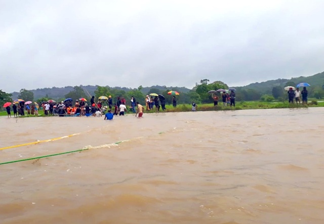
And today, as the nation reels under yet another historic catastrophe triggered by a powerful cyclone named Ditwah, the scale of devastation is again overwhelming. More than fifty people have already lost their lives, dozens remain missing, and millions have been displaced from inundated homes and shattered communities. Communication networks have fallen silent, power supplies have failed, and entire regions have been cut off as floodwaters rise and landslides continue to unfold. Even as families wait for rescue in the dark, the familiar chorus of political blame is beginning to stir. Yet the hard truth remains unchanged: disasters in Sri Lanka do not begin with rain, or wind, or cyclones. They begin long before the storm, in the choices made about land, forests, planning, governance, and preparedness. Until those choices change, the island will continue to relive its past with devastating clarity.











My comments were deleted 11 times by you. WHY ???? Is the FREEDOM TO COMMENT NOT A RIGHT IN SRI LANKA ?????? Can you believe this !!!! Very strange and unbelievable !!!! But I will persist for the 12th time.
My comments, the 12th time, were deleted before I completed the comments. I give up completely disappointed.