A major international security controversy has erupted after allegations that satellite imagery of U.S. military positions in the Middle East was published by a China-based artificial intelligence company shortly before Iranian strikes on American assets, raising questions over whether European commercial satellite systems may have indirectly contributed to a sensitive intelligence leak. The firm at the center of the dispute, MizarVision, is accused of releasing highly detailed, annotated images of U.S. forces stationed at Prince Sultan Air Base in Saudi Arabia, identifying aircraft types, base layouts, and operational positioning with unusual precision. The timing of the imagery’s appearance, followed by a coordinated Iranian attack on the same facility, has triggered heightened scrutiny in Washington over how sensitive battlefield information may have been exposed through commercial satellite networks.
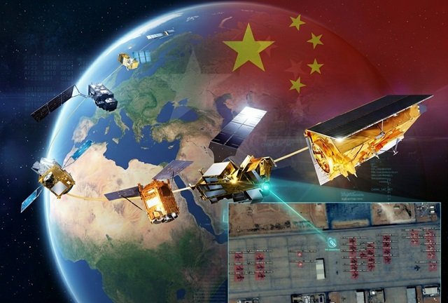
At the core of the allegations is a technical assessment conducted for U.S. congressional oversight officials, which suggests that Airbus Space satellite systems may have had multiple viable imaging windows over the region in the days leading up to the conflict. Based on orbital tracking data, daylight conditions, and sensor alignment modeling, the analysis concludes that Airbus satellites were physically capable of capturing high-resolution imagery of the base during several overlapping passes. While no direct evidence has been presented publicly confirming the transfer of imagery from Airbus systems to Chinese entities, lawmakers argue that Airbus remains among the most plausible upstream sources of the data later published by MizarVision.
The images in question reportedly showed detailed views of Prince Sultan Air Base, including U.S. E-3G Sentry airborne warning aircraft and KC-135 refueling tankers, with annotations identifying their positions on the tarmac. Defense analysts say the level of clarity in the imagery is significant because it allows for the identification of operational assets that are typically considered high-value targets in conflict scenarios. Within weeks of the images circulating online, Iranian forces launched missile and drone strikes against the base, causing casualties and damaging multiple U.S. military aircraft. Although officials have not confirmed a direct causal link between the imagery and the attack, the sequence of events has intensified concerns over the security implications of openly available satellite data.
The controversy escalated further after a letter from Representative John Moolenaar, chair of a U.S. congressional committee on China, called for an urgent review of Airbus Space’s practices and its potential role in enabling sensitive imagery dissemination. The letter warns that near-real-time commercial satellite imagery of active military bases may effectively function as targeting intelligence when published without restrictions. It also argues that once such imagery enters open digital ecosystems, it can be rapidly processed by artificial intelligence systems and redistributed in ways that are difficult to monitor or control.
The congressional assessment underlying the inquiry points to simulation modeling of satellite orbital paths, suggesting that Airbus platforms had repeated opportunities to observe the base under conditions suitable for high-resolution optical capture. These simulations considered satellite positioning, camera orientation capability, and daylight availability, identifying multiple time windows in which imaging would have been feasible. However, the analysis stops short of establishing a definitive chain linking Airbus systems directly to the imagery published by MizarVision, instead framing the connection as a technical possibility under investigation.
Beyond orbital mechanics, lawmakers are also examining broader commercial and institutional relationships within the global satellite industry. The concern is that complex partnerships between aerospace firms, research institutions, and downstream analytics companies may create indirect pathways through which sensitive imagery can be accessed, processed, and redistributed. In particular, attention has focused on how Earth observation data is shared across borders and whether existing safeguards are sufficient to prevent military-sensitive information from reaching adversarial actors during active conflicts.
MizarVision has not disclosed the sources of its satellite imagery, instead emphasizing its artificial intelligence capabilities for analyzing Earth observation data. However, independent assessments cited in the congressional correspondence suggest that the resolution of the published images exceeds what some Chinese satellite systems are currently believed to produce, narrowing the list of likely upstream providers. Several Western commercial satellite operators have denied supplying imagery to the company during the relevant timeframe, while also highlighting the difficulty of controlling downstream redistribution once imagery enters global data markets.
The stakes of the controversy are underscored by the reported impact of the subsequent Iranian strike on Prince Sultan Air Base, which damaged key U.S. aircraft including airborne command-and-control platforms and aerial refueling tankers. Military analysts warn that such losses can significantly reduce operational effectiveness in regional theaters where sustained air operations depend on specialized support assets. The apparent targeting of the same aircraft types identified in publicly available imagery has further intensified debate over whether commercial satellite data may be influencing real-world battlefield decisions.
As the investigation continues, U.S. policymakers are considering whether voluntary industry guidelines are sufficient to manage the risks posed by high-resolution Earth observation technologies during armed conflict. Some satellite companies have already begun restricting the release of imagery in sensitive regions, particularly during active military operations. However, lawmakers argue that inconsistent practices across the industry create exploitable gaps that adversaries can leverage by aggregating publicly available data from multiple sources.