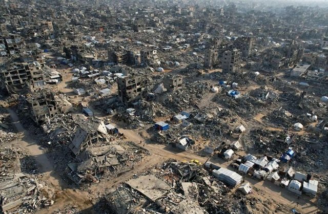
Satellite imagery from the European Union’s Sentinel programme is being withheld for 24 hours over Gaza, parts of the West Bank and surrounding areas, delaying independent verification of military activity and demolitions, according to an analysis by investigative organisation Bellingcat. The restriction, which began on March 28, 2026, was not publicly announced and has affected imagery covering parts of Israel, the Eastern Mediterranean and neighbouring territories.
The delay was identified through an examination of satellite capture and publication timestamps. Although the restriction lasts only a day, it can prevent researchers, journalists and human rights investigators from confirming developments while events are still unfolding. The affected imagery includes data from the European Space Agency’s freely available Sentinel-2 optical satellites and Sentinel-1 radar satellites, which have become increasingly important sources for open-source investigations as commercial providers restrict access to imagery of the Middle East.
Bellingcat’s analysis found that the restriction affected imagery covering Gaza and parts of the West Bank, including Hebron, where Israeli Defence Forces demolished Palestinian homes in recent days. Satellite imagery captured on October 26, 2026, could have helped researchers establish the extent of the demolitions and identify other activity in the area. However, imagery covering the western half of Hebron was not published until October 27, preventing immediate satellite-based verification of the reported events.
The European Union told Bellingcat that the delay was intended to “mitigate possible threats” arising from the war in the Middle East, including Iran’s attacks on neighbouring countries and possible threats to European interests. A spokesperson said the restriction was not related to events in Gaza. The delayed satellite region also extends across the Eastern Mediterranean Sea.
The spokesperson said decisions of this nature were taken unanimously by EU member states and would remain in place “as long as necessary”. Although the Copernicus programme generally operates under a free and open data policy, the EU said security considerations could impose limitations.
The European Union did not provide further information when asked whether the restriction was connected to the presence of US vessels in the Eastern Mediterranean or whether other areas were subject to similar delays.
Bellingcat’s findings indicate that the restriction is part of a wider pattern of satellite imagery delays across strategically important maritime and conflict regions. The organisation identified four distinct areas affected during 2025 and 2026: the Gulf of Oman, the Gulf of Aden and western Arabian Sea, the Red Sea, and the Eastern Mediterranean, including parts of Israel, the West Bank and Gaza.
The delays have been introduced in stages. Open-source researchers first observed 24-hour delays affecting Sentinel-2 imagery in March and April 2025, following the launch of a US naval and air campaign against Houthi targets in Yemen. The Eastern Mediterranean restriction began on March 28, 2026, the same month that commercial US satellite imaging company Planet Labs restricted imagery across the Middle East.
The Gulf of Oman delay began on July 15, 2026, two days after the publication of EU Council Decision 2026/1716, which ordered a 24-hour delay on Sentinel imagery over that region following a request from the US government during strikes on Iran.
The decision was subsequently unpublished. Two weeks after its release, the European Union issued a corrigendum removing Decision 2026/1716 from the Council’s official record. Satellite data nevertheless indicates that the delay continued.
The decision, while publicly available, was reportedly the first formal notification of delayed Sentinel imagery. Bellingcat’s analysis found that the restrictions extended beyond the area covered by the decision, which referred only to part of the Gulf of Oman.
The restrictions also differ between satellite systems. Sentinel-2 captures optical imagery at higher resolution, while Sentinel-1 uses synthetic aperture radar to produce lower-resolution images that can be collected at night and through cloud cover. Bellingcat found that the Gulf of Oman and Eastern Mediterranean delays affected both systems. However, the restrictions introduced in 2025 over the Red Sea and Gulf of Aden affected Sentinel-2 but were not implemented on Sentinel-1.
The extent of the restrictions can be established through the Copernicus Data Space Ecosystem, which distributes satellite imagery as large tiles identified using the Military Grid Reference System. Researchers can compare the capture and publication timestamps recorded in the satellite catalogue to determine whether imagery has been delayed.
One tile, T36RXV, covering Gaza and portions of the West Bank, the Negev and Egypt, was captured at 08:20 UTC on October 21, 2026, but published at 10:09 UTC the following day, almost 26 hours later. Its neighbouring tile, T36RYV, covering parts of the West Bank, Israel and Jordan, was published at 12:10 UTC on October 21, less than four hours after capture.
Bellingcat found that the difference between the two adjacent tiles had persisted since March 28, 2026, demonstrating that the delay was not confined to a single observation.
The restriction has particular significance because Sentinel imagery has become an important alternative for open-source investigators after commercial satellite providers limited access to conflict-zone imagery. The delays are less extensive than restrictions imposed by some commercial providers, but they can still obstruct investigations into rapidly developing events.
In Hebron, satellite imagery covering the western part of the city was published on October 27, after demolitions had taken place. The delay prevented researchers from using the imagery to verify the reported activity while it was still unfolding. The missing satellite tiles also covered Gaza, parts of Israel, Egypt, Cyprus and the Eastern Mediterranean.
Bellingcat’s analysis found that the restrictions were consistently visible across the affected regions, with no other comparable global delays identified in Sentinel-1 and Sentinel-2 publication data since 2023.