A “river of blood” is how one survivor described the aftermath of an attack on Htan Shauk Khan village in western Myanmar. “I saw shooting. I saw mass killing,” another survivor recalled, describing scenes that would later become part of a growing body of evidence documenting the devastation unfolding in Rakhine State. According to testimony collected by the United Nations High Commissioner for Human Rights (UNHRC), 20 members of one family, including three children, were killed during the assault.
Human Rights Watch reported earlier this month that the Arakan Army (AA), an ethnic armed organization fighting Myanmar’s military junta, “may have killed at least 170 Rohingya men, women, and children” in Hoyyar Siri, known in Burmese as Htan Shauk Khan, in Buthidaung Township. The rights group described the May 2, 2024 attack as a massacre. The AA has denied the allegations, maintaining that those killed were junta soldiers and Rohingya militants rather than civilians.
The attack occurred in Buthidaung, one of two townships in Rakhine State that are home to the majority of Myanmar’s Rohingya population, a predominantly Muslim minority that has endured decades of persecution in the largely Buddhist country. The violence unfolded amid fierce battles between the AA and Myanmar’s military junta as both sides fought for control of strategic territory in western Myanmar.
At least 40 villages in Buthidaung were burned during April and May 2024 as fighting intensified. Human Rights Watch reported that both the AA and junta forces committed abuses against civilians during the clashes. The military’s controversial recruitment of Rohingya civilians into its ranks further aggravated tensions and contributed to a worsening cycle of violence.
The destruction of Buthidaung has previously been documented by Bellingcat, whose latest investigation paints a broader picture of devastation across Rakhine. The organization found that evidence of civilian harm often emerges slowly because of the military’s strict restrictions on access and the control exercised by armed groups over contested areas. In the case of Htan Shauk Khan, survivors were only able to provide detailed testimony more than a year later after reaching refugee camps in Bangladesh.
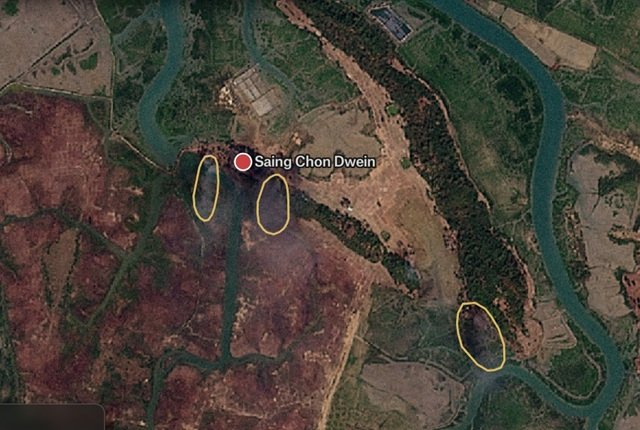
Satellite imagery reviewed by Bellingcat shows that Htan Shauk Khan was almost entirely destroyed during May 2024. The village has since become one of dozens of settlements caught in a conflict that is transforming the physical and demographic landscape of Rakhine State.
The investigation identified 115 villages that have been partially or completely destroyed since Myanmar’s military overthrew the elected government in February 2021. The findings suggest a sustained pattern of violence that has rendered large civilian areas uninhabitable and, in some cases, erased entire communities from official maps.
Among the most striking examples are the Rohingya villages of Zu La and Gone Nar in Maungdaw Township. Both communities were devastated during the 2017 Rohingya genocide before showing signs of reconstruction in subsequent years. However, fresh attacks in late 2024 once again reduced large sections of the villages to ruins. Satellite imagery captured smoke rising from Zu La after reported attacks in November and December 2024, while evidence indicates extensive fire damage throughout the area.
Today, neither village appears on the latest maps produced by the United Nations mapping unit using Myanmar government data. According to Steve Ross, a senior fellow at the Stimson Center who spoke to Bellingcat, the disappearance of villages from official records reflects a broader effort to erase Rohingya identity and presence in Rakhine State.
The phenomenon extends beyond a handful of settlements. Bellingcat found that six of the ten villages destroyed or heavily damaged in Maungdaw during 2024 no longer appear on UN township maps. Some villages that vanished years earlier remain barren landscapes. Ywar Haung has stood empty since 2017, while Kan Kya was replaced by a Border Guard Police installation.
As military control over much of Rakhine weakened, the conflict spread into new areas. The AA captured Maungdaw in December 2024 after seizing the Border Guard Police Battalion No. 5, securing Myanmar’s entire border with Bangladesh. Days later, the group announced the capture of the Western Regional Military Command headquarters in Ann Township, a major strategic victory that further undermined junta authority in the state.
The fighting left local communities trapped between advancing forces. Villages such as Pyaung Chaung were reportedly burned after residents were warned to evacuate. Satellite imagery revealed extensive destruction, while nearby settlements displayed similar signs of damage. Analysts believe some attacks were intended to make territories difficult to govern if they fell under AA control.
Attention has increasingly shifted to Sittwe, the capital of Rakhine State and one of the few major areas still controlled by the military. Analysts describe the city as a symbolic and strategic prize. Capturing Sittwe would mark the first time a non-state armed group had taken control of a state capital in Myanmar.
The junta has responded by reinforcing defensive positions around the city. Bellingcat’s investigation found villages near key checkpoints transformed into military fortifications, with trenches and defensive networks replacing residential areas. In some locations, villages appear to have been completely erased and replaced by military infrastructure designed to slow any AA advance.
Further south, fighting has intensified around Kyaukpyu Township, home to valuable oil, gas and maritime resources as well as major Chinese-backed infrastructure projects. Bellingcat identified at least ten villages that were partially or completely destroyed after clashes escalated in early 2025. Most of the damaged communities are located within a ten-kilometre radius of a junta naval base, underscoring the strategic importance of the area.
The military’s shrinking territorial control has been accompanied by a sharp increase in air and drone strikes. Data from the Armed Conflict Location and Event Data Project (ACLED), analysed by Bellingcat, shows that military strikes in Rakhine surged from 30 incidents in 2023 to 461 in 2024 after the AA resumed its offensive. By the end of that year, the AA had captured all but three of Rakhine’s townships.
Analysts say the military often targets villages to deny armed groups shelter and logistical support. However, the consequences for civilians are severe. Entire communities are displaced, livelihoods are destroyed, and populations are forced to flee repeatedly as front lines shift.
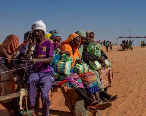
The human cost continues to mount. According to UNHRC data, nearly half a million people were internally displaced across Rakhine State by March 2026. In Sittwe Township alone, approximately 120,000 Rohingya remain displaced from earlier waves of communal violence. Across the border in Bangladesh, around one million Rohingya refugees continue to live in camps, unable to return home.
For many, the greatest uncertainty is not who will ultimately control Rakhine State, but whether the villages that once defined their communities will still exist when peace eventually returns. As Bellingcat’s investigation demonstrates, the conflict is not only redrawing military front lines. It is reshaping the map itself, leaving behind a growing number of places that survive only in memory.